Conservation
Our Conservation ApproachTrout Unlimited believes that conservation should be a true partnership between landowners, agencies, municipalities, and all stakeholders. We work to protect critical habitat, to reconnect degraded waterways, and restore populations to coldwater fisheries. Through sound science, we inform our priorities with critical data on the health of these fisheries.
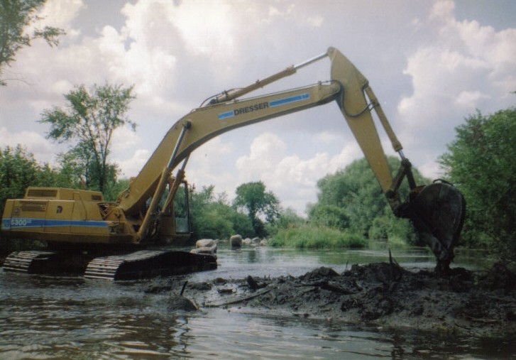
Prairie River Heineman Road
|
ProtectWatersheds and wild places are home for North America’s coldwater fisheries. By working in partnership with key players Trout Unlimited strives to protect these places for future generations of anglers
ReconnectA large-scale vision is Trout Unlimited's philosophy for how we see river ecosystems. Reconnecting streams and improving fish passage is a critical part of our conservation work - because we believe a river united is greater than the sum of its disconnected parts.
RestoreBy working effectively in on-the-ground partnerships, we help communities restore degraded trout and salmon waters to be once again thriving fisheries
ScienceThrough the detailed work of TU’s dedicated science team, we are able to monitor population resources, habitat conditions, and future impacts to angling. This helps us identify priority areas of need for our protect, reconnect, and restore work.
|
2015-2016 Prairie River Project
PowerPoint presentation provided by Ben Rolling WDNR fisheries technician and project manager.
Prairie River Dagis to Gross Road Project
Prairie River 2020-2021 Dagis Road to Gross’s Bridge
Lincoln County
Town of Russell
Township 33N Range 8E. Section 11
Stream Rehabilitation Project
May 15, 2020 through September 15, 2021
Start Location: 45.366521 -89.45895
End Location: 45.35456 -89.46373
Taylor Curran
Fisheries Technician Advanced
Wisconsin Department of Natural Resources
Antigo, WI
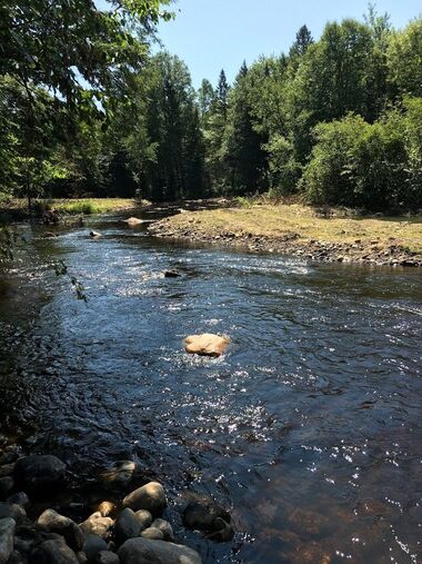
The Prairie River is a class 1 trout stream that has populations of naturally reproducing native brook trout (Salvilinus frontinalis) and naturalized brown trout (Salmo trutta). The Prairie River is listed as a Wisconsin outstanding and exceptional water resource. Sand, gravel and cobble make up much of the stream substrate within the project area. The Prairie River originates in northwestern Langlade County. The Prairie River flows southwesterly into Lincoln County where it counites a southwesterly flow until it joins with the Wisconsin River in the City of Merrill.
The Prairie River has been historically negatively impacted by dams, beaver dams, logging, log drives and agricultural practices. Impairments of the Prairie River include: widening and shallowing of the stream channel causing water temperatures to increase, erosion of stream banks, and sedimentation causing siltation of trout spawning areas. The stream is also void of large complex woody and rock habitat preferred by trout. Beaver control practices and beaver dam removals have been conducted and monitored to prevent further damages to the Prairie River.
The purpose of this document is to introduce a proposed in-stream habitat restoration project on the Prairie River. The proposed project will include the following: brushing, channel shaping, point bar construction, and the installation of complex woody and rock habitat. All work will be conducted within the stream’s ordinary high water mark to avoid any disturbance to nearby wetlands. This project will take place on two perpetual easements owned by the State of Wisconsin on the Peterson and Gross properties. This project will begin at the bottom of a natural hydraulic control at upstream (northern) end of the Peterson easement. This project will continue through the Peterson and Gross easement totaling 6,000 feet of stream. The project will end on the downstream (southern) end of the Gross easement, just upstream of an old farm bridge.
We will be repairing five wing deflectors, creating fifteen-point bars and two islands. Channel shaping will be conducted to increase lateral movement of the stream. To achieve this point bars will be constructed on inside bends and in wide shallow areas. Point bars will be constructed using spoils dug from the newly shaped channel. The point bars will ultimately narrow the stream. This will increase the depth of the stream and allow the stream bed to stay flushed down to desirable gravel and rubble substrates. The channel shaping will result in creating a series of pools, runs and riffles. The natural riffles present will remain as they are and will be enhanced with the addition of rock and large wood. Channel shaping will also increase the thalweg velocity of the stream helping to maintain cold water temperatures and provide areas for silt and sediment to settle out in slower and shallower slack areas. This will also help expose and maintain silt free spawning areas. Once the point bars are established, they will ultimately vegetate creating a new stable bank. Over time, the newly created banks will result in the succession of native vegetation leading to the establishment of mature timber on the stream bank.
Point bars will vary in width, they will be a minimum of one third (twenty feet) the width of the stream channel to a maximum of two thirds (fifty feet) the width of the stream channel. The overall length of the point bars will vary from forty to one hundred feet. The stream depth will increase to a maximum of five feet in pools. The stream depth in runs with be increased to a maximum of four feet. The island dimensions will fall into the same parameters as the pool and run sections. Approximately 16,000 cubic yards of material will be redistributed within the stream channel to repair the wing dams, create point bars and create islands.
As the channel shaping and point bars are being constructed complex wood and rock habitat will be installed. Approximately 80 logs or sections of whole trees will be placed in various areas of the stream to provide additional foraging, resting, and overhead cover for trout. The woody habitat will be buried and anchored in the stream using cable and earth-anchors to prevent the materials from dislodging and moving. Rocks will be placed in various areas of the stream to aid in holding placed wood and to help catch and hold future wood that recruits naturally to the stream. Approximately 250 small rocks around two to three feet in diameter and 250 large diameter rocks around four to five feet in diameter will be placed in the stream.
Tag alder will be cut from the stream banks. Native trees will be planted on the newly created point bars in future year(s). This will help suppress tag alder encroachment and provide a shaded canopy over the stream, helping keep stream water temperatures cool and also to allow for mature trees over time to naturally fall in and become large woody habitat in the stream.
Goals of this project will be: narrowing and increasing depth of the stream channel, increasing the amount of complex wood and rock habitat in the stream and suppressing tag alder growth while encouraging recruitment of mature timber (habitat) into the stream within the riparian area. This project will increase resting and foraging habitat and improve spawning sites for trout.
We will be utilizing established trails/roads for equipment, worker and material transportation to access the project area. Any exposed soil will be seeded with a clover, rye, and oats cover crop and be mulched with straw to prevent erosion.
Equipment used on this project will include: an excavator, bull dozer, tracked UTV, chainsaws, mauls, pumps, a hydraulic hammer and other hand tools. Post completion, this project will be monitored and maintained by Antigo DNR fisheries.
Dagis Road Overview
| prairie_river_2020.2021_dagis_rd_to_grosss_bridge_site_map.pdf |
Dagis Road Detailed
| prairie_river_dagis_rd_2020.2021_plans.pdf |

